|
|
 |
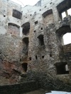
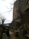
HomburgLäufelfingen, BL (CH)GPS coordinates: N 47°24.183, E 007°51.309, 850m above sea level Build in the year 1240 by Count Hermann IV of Froburg and sold in 1303 to the Bishop of Basel and in 1400 to the city of Basel. This allowed Basel to secure the passage over the Hauenstein mountain and to control the countryside. In the aftermath of the French revolution, local farmers attacked and burned that castle in 1798. The copper engravings depict the situation of 1750.
| ||||||||||||||
|
|
||||||||||||||||


